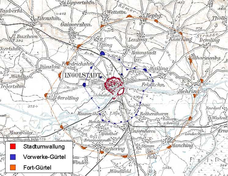
Ingolstadt impresses with its architectural splendour and rich history. Fortified and constantly expanded from the 13th century onwards, the Kingly Bavarian State Fortress set new standards in the 19th century as the most modern polygonal fortification of its time. Two fortification rings with over 30 outer forts form the forward barriers of the large fortification system.
Visit the Bavarian Army Museum in the late-medieval New Castle or stroll along the medieval and modern city ramparts and enjoy the many walking paths in the Glacis or along the Künettegraben. Also switch to the southern side of the Danube and explore the classicist Reduit Tilly, the centrepiece of the bridgehead with the two flank batteries and the Klenzepark.
With FORTE CULTURA, discover Ingolstadt, the City of Transformation , where fortress history and modernity combine in a fascinating way.
Monument and History
History
Due to its location on the Danube, Ingolstadt was already an important crossroads of long-distance traffic routes in prehistoric times and later in Roman times. The first mention of Ingolstadt can be found in a document of Charlemagne in 806. Around 1270, Ingolstadt demonstrably had a city wall, of which the Old Castle (today known as the Herzogskasten) still exists and is used as the city library.
Due to the division of Bavaria into two duchies, Ingolstadt became the capital and residence of the Duchy of Bavaria-Ingolstadt in 1392 (1392-1447). The construction of the second medieval city wall, begun as early as 1368, was completed by 1430. The city wall contained 87 semicircular towers, which is why Ingolstadt was given the nickname "the Hundred Towers".
In 1472, the first university in Bavaria was founded in Ingolstadt, which later distinguished itself as a centre of the Counter-Reformation. Ingolstadt was also an important trading centre for salt, wine and beer.
In 1537 Ingolstadt became the Bavarian state fortress of Ingolstadt and was expanded as a bastioned Renaissance fortress from 1539 to 1565. This gave it the nickname "Die Schanz".
As early as 1546, during the Schmalkaldic War, troops of the Schmalkaldic League and the imperial troops of Charles V clashed outside the city gates of Ingolstadt for two weeks, but without any major consequences.
During the Thirty Years' War, Gustav II Adolf of Sweden shelled Ingolstadt from the south. However, he broke off the attempt to take the city after a week following heavy losses. Whether the fact that his horse was even literally shot "out from under him" during a reconnaissance expedition contributed to this is still disputed today. After the Swedes withdrew, the animal was brought to the city and prepared. The "Swedish grey horse" can be seen today in the city museum and is considered the oldest preserved taxidermy in Europe.
During the War of the Spanish Succession, Ingolstadt was besieged again in 1704 without success. However, the fortress was surrendered under the Treaty of Ilbesheim and remained under the administration of imperial troops until 1715.
In 1799, Napoleonic troops occupied the fortress of Ingolstadt. The university was transferred to Landshut and the fortress was ordered to be razed.
As early as 1806, it was decided to rebuild the fortress, but due to a lack of funds it could not be realised until 1828. The Royal Bavarian Mainland Fortress became the largest and most expensive building project during the reign of King Ludwig I. In 1861, the classicist fortress housed around 12,750 soldiers of the Bavarian army - compared to around 7,000 Ingolstadt citizens.
From 1866, the Vorwerkgürtel (middle ring) was built around the city, followed by the outer Fortgürtel from 1875.
The construction of the fortress strengthened the transport infrastructure: in 1867 a railway connection was established, and businesses such as the "Königlich Bayerische Geschütz- und Geschoßgießerei" (Royal Bavarian Gun and Bullet Foundry) ensured an economic upswing.
During the First World War Ingolstadt was at times occupied by over 40,000 soldiers, the fortress buildings were used as prisoner-of-war camps and two reserve hospitals were set up in the city.
In 1937, the city's status as a fortress was revoked. By 1938, the approximately 100 Jewish residents had been expelled. In 1944, Fort VIII (Manching) became a Wehrmacht prison, in which 76 members of the Wehrmacht were executed by the end of the war for undermining military morale or desertion. From January 1945, the town was the target of Allied bombing raids.
After the war, emergency accommodation for refugees was set up in the fortifications. From the mid-1950s, the pioneer barracks on the Schanz were built as Bundeswehr barracks: Today it houses the Pioneer School, the Army Technical School for Civil Engineering and the Centre for Civil Engineering as well as the Mountain Engineer Battalion 8.
Quelle: Ausschnitt © Bayerisches Armeemuseum, Ingolstadt Quelle: Lithografie von Anton Hoffmann 1896 Quelle: © Matthäus Merian
Architecture
The first and oldest city wall was built in the 13th century and consisted of a rectangle with 4 corner towers. The Old Castle - today called the Duke's Box - was part of the fortification and is today the only remnant of this first medieval city fortification.
From 1368 to 1430, the second medieval city wall was built. A 6-8 metre high city wall and 87 semicircular towers at intervals of about 30 metres secured the city and earned it the nickname "the hundred-towered one" (lat. ad centum turres). It has almost been preserved, worth seeing are the Kreuztor, the Münzbergturm and the old Feldkirchner Tor.
In 1539, the foundation stone was laid for the construction of the first Bavarian state fortress. Until 1565, a bastioned Renaissance fortress was built on both sides of the Danube under Duke Wilhelm IV, planned by Reinhard Graf Solms zu Münzenberg and executed by master fortress builder Georg Stern. The New Palace was also fortified with bastions and further ditches.
Under master fortress builder Christoph Heidemann, further reinforcements took place in the 17th century. He had the inner moat wall raised and placed detached bastions, mostly in the form of a lunette, in front of the existing bastions. Three additional bastions were also built and the Harder Gate, which was considered a weak point, was closed.
After the fortress was razed by Napoleonic troops, it was rebuilt from 1828 as a classical polygonal fortress and two fortification belts (from 1866 and 1875). This made Ingolstadt a "fortress of the first rank", providing sufficient space for the Bavarian army to prepare for campaigns and sufficient cover and storage space after campaigns. In addition to the purely defensive buildings, the military authorities also erected numerous supply and residential buildings, turning Ingolstadt into the industrial "armoury" of the Kingdom of Bavaria, with a powder factory, bullet factory and ammunition factory. It was the second largest armaments location in the German Empire after Spandau at this time.
After all, with a wartime garrison of 30,000 men and a stockpile of 400 guns, the Ingolstadt fortress was considered highly resistant and no enemy was expected to be strong enough for a formal attack.
After the Second World War, all the fortifications of the outer fort belt were blown up, with the exception of Fort Prinz Karl (Fort VI) near Katharinenberg near Großmehring. However, considerable remains can still be found on some of the rubble sites, and the outlines are usually still clearly visible on aerial photographs.
Detailed descriptions of the construction stages and development phases of the state fortress can be found on the website of the Förderverein Bayerische Landesfestung Ingolstadt e.V. at www.www.festungingolstadt.de .
Quelle: Stadt Ingolstadt Quelle: © nach Kleemann, Förderverein Bayerische Landesfestung Ingolstadt e.V. Quelle: © Christian Karl
Nature Experience
Ingolstadt has numerous parks, extensive green spaces and forests. The most characteristic is the glacis, the apron of the former fortress belt around the actual city centre. In the 19th century, the glacis was laid out as part of the state fortifications as an open, grassy firing field in front of the fortifications. The 100-hectare green belt enclosed the old town with areas of woodland, meadows and water. Attackers found no cover here. Today, Ingolstadt residents and visitors alike enjoy a green oasis that radiates harmony between nature and historic fortifications. Extensive footpaths and cycle paths open up the idyllic nature belt.
In the midst of the magnificent fortifications of the bridgehead is the Klenzepark, laid out on the occasion of the State Garden Show in 1992 with meadows, avenues, water features, a rose garden, perennial areas and a plant labyrinth. Children will love the Fort Peyerl play park. A beer garden and the Gardens of the Senses also attract visitors to Klenzepark, which is also the venue for top-class open-air events.
The largest forest in Ingolstadt is the Auwald (Schüttel) on the northern and southern banks of the Danube. It is one of the largest continuously preserved floodplain forests in Germany. The floodplain forest serves as a nature reserve with vegetation and animal species that are partly unique in the region, and also as a green lung and (near-natural) recreation area.
Along the Danube there are further nature and recreation areas as well as a biotope adventure trail in three sections.
(www ingolstadt.de/biotoperlebnispfad ).
Quelle: © Maximilian Schuster Quelle: Stadt Ingolstadt Quelle: Stadt Ingolstadt Quelle: Gartenjournal.net