Contact
Germersheim Tourism, Culture and Visitors Centre
Weißenburger Tor, Paradeplatz 10
Phone: +49(0)7274/960-3
E-mail
Website
Flyer Festungerbe Oberrehein
The history of fortifications in the Upper Rhine region stretches from simple wooden fortifications and earthen ramparts dating back thousands of years, to Roman forts and the Limes, to medieval castles and city walls. The introduction of firearms led to completely new fortification elements for castles, palaces and towns. New, powerful fortified towns and fortification systems emerged and have been steadily strengthened and expanded, especially in the last 350 years. From confrontation to partnership
FORTE CULTURA® Travel Recommendations
Experience World
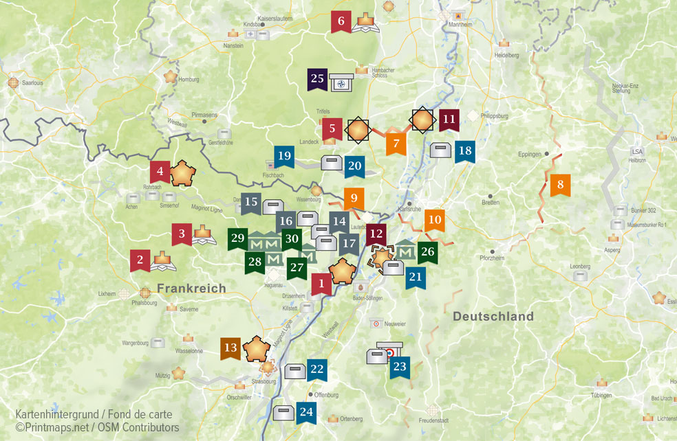
Overview of the participating fortress sites and museums
1 - 6 ➩ Vauban's heritage - Fort-Louis, Castle Lützelstein, Château Lichtenberg, Citadel Bitche, Fortress Landau, 7 - 10 ➩ Lines and redoubts - Queich line, Eppingen lines, Weissenburg line or Lauter line, Ettlingen lines11 - 12 ➩ German Confederation - Fortress Germersheim, Federal Fortress Rastatt13 ➩ Imperial period fortifications - Fort PODBIELSKI – DUCROT 14 - 17 ➩ Maginot Line - Casematte Rieffel, Maginot Line “ Four-à-Chaux” Lembach, Fort Schoenenbourg Hunspach, 18 - 24 ➩ West fortifications - Bunker museum Dettenheim-Rußheim, Westwall Museum Bad Bergzabern, Westwall Hiking Trails, 25 ➩ Cold War - NATO Bunker St.Martin26 - 30 ➩ Museen - Rastatt Museum of Military History, Museum Abri Hatten, 2MCLADN Museum Walbourg 1870->1945,
1 - Fort-Louis
On the instructions of the Sun King Louis XIV, the ingenious fortress builder Vauban built a strong fortification with two bridgeheads on an island in the Rhine from 1687 to secure the north-eastern border of the kingdom. 100 years later, the fort had grown into a fortified garrison town with 4,000 inhabitants before the Prussians and Austrians besieged and destroyed it in 1793/1794. After the military function was abandoned, the military site was sold to the municipality in 1870. As a testimony to a prestigious military history, the ground plan of the fort and the bridgehead are mapped in nature, a discovery for history lovers and hikers.
2 - Château La Petite Pierre (Castle Lützelstein)
The fortified town of La Petite Pierre is located in the heart of the Vosges du Nord Regional Nature Park, 25 km from Saverne and 60 km from Strasbourg. Modernised by Vauban, the fortified castle sits on an imposing sandstone spur and was a strategic point for controlling the passage between Alsace and Lorraine. Since 1975, it has been the seat of the Vosges du Nord Nature Park. Discover the "Staedtel" (old town), the castle, the Seal and Springerle museums, 15th century frescoes, gardens and impressive sandstone spurs. On the rampart path (approx. 30 min) you can explore the extent of the grounds and underground cisterns. On the ground floor of the castle, a boutique area and, in the courtyard, a new open-air discovery trail invite you to discover the history of La Petite Pierre, its castle and its inhabitants.
3 - Château of Lichtenberg
When modernity meets the Middle Ages ... From the terraces of Lichtenberg Castle, the colossal ruins of pink sandstone overlooking the village of the same name, an extraordinary panorama opens up. The fortress is proud of its turbulent history dating back to the 13th century. This stately home, a garrison, is now a cultural and tourist site. You should explore this "ship of centuries". Discover the history of the castle with family or friends. Display boards and activity boxes, marked trails and many seasonal activities reveal all the secrets. Boutique area and cafeteria with terrace and deckchairs invite you to have a drink with a magnificent panoramic view of the northern Vosges.
4 - Citadel of Bitche
The citadel of Bitche stands proudly on a rock with its mighty walls flanked by bastions. The castle of the Dukes of Lorraine was turned into a citadel between 1680 and 1754 by the famous Marquis de Vauban and architect Cormontaigne on behalf of French kings. It bears all the hallmarks of 17th and 18th century military architecture. In the labyrinth of underground passages, visitors are immersed in the events of the historic siege of 1870-1871 thanks to life-size cinematographic reproductions. The restored chapel displays the relief map of Bitche. Interactive terminals allow visitors to discover the architectural details. The museum "Men in the War of 1870" offers a realistic overview through archival images and stories of soldiers. The panoramic route is an excellent way to explore the upper plateau with its 13 monuments.
5 - Fortress Landau
Vauban recommended fortifying Landau as a possible gateway into Alsace. This was done in 1688-1691 at enormous expense. A 7 km long canal was built to transport the building materials south of the Queich from Albersweiler to Landau. In 1689, the military administration "corrected" the townscape in the western part of the town, which was built with numerous half-timbered houses, by setting fire to it at night. The new fortress with its 2278 m long main rampart was militarily highly modern, but was repeatedly captured during sieges. In the 18th and 19th centuries, the fortress was structurally improved with new works and barracks. The town gates, parts of the lock system and the "Red Barracks", Lunette 41 and the fort have been preserved from the 17th century fortress. In 1831, Landau was incorporated as a federal fortress to protect it against France. The Chopin Quarter (19th century) was preserved. After the fortress was dismantled in 1873, the ring road architecture was built in place of the ramparts.
6 - Hardenburg Castle and Fortress Ruin
In Bad Dürkheim, above the valley of the Isenach, is the Hardenburg, once one of the most powerful castles in the Palatinate. The complex is considered a prime example of a fortified castle, a mixture of fortress and castle. Built at the beginning of the 13th century as a modest hilltop castle, the Hardenburg was expanded in the 16th century into a fortified Renaissance residence. Mighty walls and bulwarks, turrets, gates, battlements and catacombs still bear witness to its fortress-like character.
7 - Queich line
The Queich lines were built as field fortifications during the War of the Austrian Succession from 1743 onwards from Annweiler via Landau to the Rhine. East of Queichheim, the Queich was completely diverted in 1744/45. Approximately 30 dams with upstream redoubts were built for large-scale flooding. The lines were planned by French military engineers (including Cormontaigne). With the beginning of the Revolutionary Wars in 1792, the ramparts of Offenbach, Ottersheim and Bellheim were reinforced with redoubts and a redoubt was built in Hördt, the moat of which still shows the outline of the complex. When the left bank of the Rhine became part of France, the Queich lines lost their military importance.
8 - Eppingen lines
Margrave Ludwig Wilhelm of Baden, known as "Turk Louis" because of his successes against the Turks, had an 86 km-long defence system with ramparts, ditches, verhack and palisades built between the Black Forest and the Odenwald between 1695 and 1697 - the Eppingen Lines. In the Stromberg-Heuchelberg Nature Park, follow the course of the rampart-ditch system from Eppingen to Mühlacker on the cultural-historical quality hiking trail Eppinger-Linien-Weg through the varied landscape. Parts of the Eppingen lines such as wooden watchtowers (chartaques) have been reconstructed. Where the Stromberg once served military strategic purposes, today magnificent views delight. Nine large sculptures by the Gemmingen artist Hinrich Zürn present the history of the Eppingen lines, the effects of the historical war events on the population of the region and the present situation in united Europe.
Wissembourg line or Lauter line
To defend his territory, Louis XIV had the Lauter lines built in 1706. This was an earthen wall several metres high, supplemented by a moat, fifty outworks and dams to flood the Bienwald. These defensive lines ran for about twenty kilometres along the Lauter between Wissembourg and Lauterbourg. They were still in use during the Revolutionary Wars.
10 - Ettlingen Lines
The Ettlingen lines were established in 1707 during the War of the Spanish Succession (1701-1713/14) and were intended to hold off the French on the right bank of the Rhine. In 1733 and 1738, they were further strengthened and expanded. They consisted of 5-metre-deep ditches with wooden entrenchments and metre-high earthen ramparts with palisades (oak stakes). The Ettlingen lines ran from the Rhine, north of Karlsruhe to Dobel and into the Eyach valley, connecting with the Eppingen line and the Black Forest line. The Ettlingen lines were part of the complex defence system that stretched from Neckargmünd to the High Rhine. About 100 m in front of the lines stood 10 m high watchtowers, so-called chartaques, at regular intervals. Replicas of such wooden watchtowers can be seen near Eppingen and Mühlacker and on the Waldschanz south of Niefern-Öschelborn. Relics of the defence line such as ditches and mounds can be discovered and admired on the 11 km long trail with information boards in the Hardtwald (Rheinstetten) and in the forest between Ettlingenweier and Spessart.
11 - Germersheim Fortress
The imposing fortress town of Germersheim was built from 1834 to 1861 by order of the Bavarian King Ludwig I as a "bulwark against France". However, the largest Bavarian fortress outside Bavaria still shines in all its glory today.
12 - Federal fortress Rastatt
Construction of the Federal Fortress of Rastatt began on 15 November 1842. The construction of the federal fortress was divided into three forts: the Leopoldsfeste, the Friedrichsfeste and the Ludwigsfeste. Only a few buildings from the Rastatt fortress period from 1842 to 1890 are still standing today. Many ramparts and ditches were levelled, other forts were demolished and their stone material used to build town houses. The Karlsruhe Gate, the Kehler Gate, the garrison hospital, the Körnermagazin (Grain magazine) and the Lünette 42 have been preserved to this day. Today, visitors can see the underground battlements of Bastion 27 at the Karlsruher Tor and the casemates on the Südring, the former Contreescarpe gallery.
13 - Fort PODBIELSKI – DUCROT
Fort Podbielski is the "youngest" of the 14 forts in the Strasbourg fortification belt. It was built between 1879 and 1882 on the heights of the village of Mundolsheim and was rebuilt several times until 1893. After 1911, it was reinforced by two cannon-loaded casemates (east and west). At the end of World War I, it became Fort Ducrot. In 1936, the façade was covered with a thick reinforced concrete shield to integrate it into the Maginot Line as a command post. After the Second World War, the fort was abandoned by the state. In the 1990s, the municipality bought it to secure it. The association "Friends of Fort Ducrot" was founded in 2010 and started the reconstruction work with the support of the municipality. After 10 years of work and 45,000 volunteer hours, the fort looks great again.
14 - Maginot Line - Casemate Rieffel
Built in 1930, the Oberroedern-Sud casemate is part of the main resistance line of the Maginot Line. It was commanded by Lieutenant RIEFFEL. As one of the first casemates, it has some special features. It consisted of 2 levels and 1 guard bell, 2 firing chambers, a room for the soldiers and a room for the generator. In June 1940, it was bombed and attacked when the Wehrmacht tried to break through the Maginot Line in Oberroedern. Restoration began in 2001 with the founding of the ALMO association. Open to the public since 2008 and newly equipped, visitors can rediscover the atmosphere of French soldiers in 1940 here.
15 - Maginot Line - Fortress “le Four-à-Chaux” Lembach
The casemates of the Maginot Line are part of the landscape of northern Alsace. The Four-à-Chaux site in Lembach was built in concrete and steel from 1930 - 1935 to defend the Franco-German border during World War 2. As one of the main sites of the defence line, the casemates were equipped with an electric inclined lift, unique in Alsace. Perfectly preserved, it still contains many historical devices. Guided by volunteer guides, visitors discover the barracks, where 580 crew lived, the kitchen, the dormitories, the hospital, the officers' quarters and the central command post at a depth of up to 30 metres. In the fighting blocks, the tour guide demonstrates the functioning of the artillery turret. The engine room, multi-purpose room and a museum are to be discovered. Life in the Maginot factory and the workings of this World War 2 defence line are vividly conveyed.
16 - Maginot Line - Fort Schoenenbourg in Hunspach
The Schoenenbourg Artillery Fort is the largest fortress of the Maginot Line that can be visited in Alsace. It is fully and authentically equipped with all the elements and can be explored on 3 km of the underground route, 30 m underground and the 2.5 km outdoor discovery trail. Fort Schoenenbourg has become a link between peoples and is maintained and managed by the Association of the Friends of the Maginot Line of Alsace (AALMA). Built in 1931 - 1935 using state-of-the-art technology by 200 civilian workers, it held a crew of 630. In 1939/40 it was bombed by the Luftwaffe and heavy artillery of the Wehrmacht. In 1940, Fort Schoenenbourg was hit by more than 3,000 German bombs and shells. It remained operational. The fort's guns returned the favour with almost 17,000 cannon shots. Attacked but undefeated, the garrison of Fort Schoenenbourg did not lay down their arms until six days after the armistice took effect in June 1940, on formal orders from the French High Command.
17 - Maginot Line- casemate “Esch”
The Esch casemate is located near Hatten, about 13 km southeast of Fort Schoenenbourg. As a casemate, it is an independent defence structure of the Maginot Line. From 1930 to 1931, it provided space for a crew of 24 and was equipped with embrasures for machine guns and anti-tank guns for close-range defence. The casemate is open to visitors during the summer months. The outside facilities can be visited and provide a good insight into the defence strategy of the Maginot Line. A museum provides information on the weapons technology of the time and the battles of 1940 between the Germans and the French and 1944/45 between the Americans and the Germans. The Association des Amis de la Ligne Maginot D'Alsace AALMA offers regular guided tours of Fort Schoenenbourg and the Esch casemate.
18 - Bunker Museum in Dettenheim-Rußheim
The bunker belongs to the rare category of medical shelters, i.e. in case of emergency injured soldiers were to be treated here until they could be transported to the military hospitals. Its designation is Regelbau 32 (R32 for short). This type of Regelbau was only built 81 times in the Westwall. It is the only surviving R 32 in Baden-Württemberg. With a ceiling and wall thickness of 2 m and the typical rounded ceiling edges, this facility is one of the bunkers of the Oberrheinstellung begun in the winter of 1938/39, built by the Reich Labour Service. Later it was used as an air raid shelter for the civilian population. The bunker houses an exhibition of civilian and military objects from the period between 1933 and 1945.
19 - Westwall Museum Bad Bergzabern
The last 3 remaining bunkers of the Westwall in the Southern Palatinate are now area and route monuments of the Nazi era. The bunkers and museum grounds are the property of the town of Bad Bergzabern and are run by volunteers. The primary purpose of the Westwall was to prevent the western democracies from influencing Hitler's wars of aggression to the east, both propagandistically and practically. Bunker 2 provides information on the connection between the construction of the West Wall, the expropriation and partial forced displacement of the inhabitants of the border strip, the militarisation of broad sections of the population, and the establishment of the Hinzert special camp for non-"cooperative West Wall workers".
20 - Westwall hiking trails Bad Bergzaberner Land and Schaidt
The Westwall: 620 kilometres of fortifications stretched along Germany's western border between Wesel and Basel from 1936. Thousands of bunkers, trenches, hump lines and minefields were intended to make it impossible for the enemy to penetrate the Reich. Today, enemies have become neighbours and nature has reclaimed its terrain. Learn what the construction and demise of the West Wall meant for the people, whether soldiers or civilians in our region, for nature with its flora and fauna. WestWallWeg Bad Bergzaberner Land - Hiking Trail Follow the "Otterbachabschnitt", bunker remains and hump lines, one of the most heavily fortified sections of the Westwall. The WestWallWeg leads you along the Westwall through the middle of picturesque nature. WestWallWeg Schaidt - Hiking Trail Combine contemporary historical information with an unforgettable nature experience on the Westwall hiking trail Schaidt between the Bienwald forest and the border to neighbouring Alsace. On the small and the large circular trail you will see remarkable relics of the fortifications, water-filled armoured trenches, hump lines, gun emplacements and bunker ruins, today valuable habitats for wildcats, bats, lizards and other cave creatures. Overview boards with numerous pictures and comprehensive information enrich your foray through history, such as remains of the former B-Werk "Kiefernwald", Turko graves", Bismarck oak, picture oak Start/end: Schaidt hiking station (large car park)
21 - Westwall Bunker Rastatt
The Westwall bunker on Kehlerstraße is not the largest, but the most frequently built (standard construction 10/ fortified shelter for 15 soldiers) and undestroyed. With metre-thick walls and heavy iron doors, crouched in a hollow. This is how the last intact Westwall bunker in Rastatt presents itself. It is quite different from the bunkers of the French Maginot Line with their enormous dimensions. Taken over by the French, it served as a prison after the war, escaped the obligatory demolition and later became visibly littered. After the French left, the Historischer Verein Rastatt/ Rastatt Historical Society took over the bunker and restored it. Guided tours by the association are offered on fixed dates or by appointment.
22 - Camouflage Bunker Kehl-Neumühl
Some West Wall bunkers were given superstructures and painted to make them look like houses. The "Tarnbunker" in Kehl-Neumühl is one of these. Built in 1938 as Regelbau 10a, it was equipped with an attic in 1939, which was inhabited from that time on. This camouflage structure was demolished in 2007 despite the structure's listed status. From 2012 to 2015, the concrete filling that had rendered the bunker unusable in 1947 in lieu of a blast was painstakingly removed. Since 2017, the structure has been looked after by the "Tarnbunker Neumühl" support association, which has set itself the goal of rebuilding the original camouflage structure. A visit to the "Tarnbunker" can be supplemented with visits to the older generations of fortifications built around Kehl and Strasbourg by the French kingdom (Vauban), the German Confederation, the German Empire and the French Maginot Line.
23 - Hornisgrinde Bunker
Hornisgrinde Bunker - 60 years of restricted military area 1939-1999. The Hornisgrinde is the highest mountain in the northern Black Forest with views as far as the Vosges, the Alps and the Swabian Alb. and was a restricted military area until 1999. Traces of this past can be found all over the mountain plateau and hold a few surprises. With certified guides, interested visitors gain insights into the 60-year military history of the mountain. During the guided tour, you slip through a hidden entrance into the Hornisgrinde bunker, the only surviving bunker from the Cold War era, and learn exciting details about its origin and purpose. Back on the surface, enjoy the unique view from the summit plateau with its high moor and its special flora and fauna. The anti-aircraft position from 1939 and other legacies of the military era can be discovered.
24 - Museum Bunker Emilie - Neuried Altenheim
The Museum Bunker Emilie is one of the few surviving structures of the Westwall, which stretched from Kleve to Basel with its approximately 18,000 bunkers. The bunker was named after Emilie H., who lived in the camouflage building above the bunker during the war and continued to live there until her death in the early 1980s. Since 2009, Regelbau 11 has housed a museum, which was initially financed from private funds. In 2017, the association "Museumsbunker Emile e.V." was founded, which now takes care of the preservation of the bunker. "Emilie" can be visited on request.
25 - NATO Bunker St.Martin
The telecommunications systems of the "Cold War" served to operate a secure, independent military communications network. 27 GSVBw nodes (basic network, switching and exchange points) were distributed throughout Germany. GSVBw 47 Niederbrombach and GSVBw 44 St. Martin were a special design. The telecommunications operations rooms were built in a tunnel system and were called underground GSVBw. The St. Martin facility covers 3000 m². Service rooms were arranged in longitudinal tunnels (120 m) and transverse tunnels (72 m) with 6 m height. The connecting gallery between the main and emergency exits is 480 m long. A special feature is the water gallery, which was to ensure an independent supply of personnel and technology. While GSVBw 47 in Niederbrombach was equipped with telecommunications technology and space for 50 - 60 men and went into operation, St. Martin remained a shell. Expansion measures were discontinued in 1972. The St. Martin facility was acquired by the municipality in 1997.
26 - Wehrgeschichtliches Museum Rastatt/ Rastatt Museum of Military History
The Wehrgeschichtliches Museum Rastatt/ Museum of Military History in Rastatt is one of the most important military history museums in the German-speaking world. Rastatt's location on the border with France has often placed it at the centre of European-German politics and armed conflicts. Founded in 1934, the museum has been housed in Rastatt Castle since 1956. The focus is on the relationship between state, society and military in the period from the end of the Middle Ages to the end of the First World War. Marvel at a large diorama on the "Battle of Slankamen" (1691) with 5,000 pewter figures, a relief model of the federal fortress of Rastatt (1860) and artillery models from 1820 - 1860. Exhibitions on fortifications, foundations and new additions to the museum are planned for 2021.
27 - Museum of the Abri Hatten
The large shelter "ABRI" of Hatten is located about 50 km from Strasbourg and 40 km from Karlsruhe. A total of 19 fortifications of the Maginot Line were built in the Hatten area. With a capacity for 220 men, "ABRI" was the largest. The bunker was built from 1930 onwards with all the necessary equipment to house and supply a company in case of war. The large shelter was occupied by French troops from 1936 to July 1940. A total of 28 rooms including dormitories, kitchen, toilet, well, infirmary, boiler room, engine room, venting equipment (filter room against gas) and close defence equipment have been restored and can now be seen in the museum. The museum is dedicated to the memory of all the victims of 1939-1945.
28 - 2MCLADN Museum Walbourg 1870->1945
Since May 2020, the Musée Mémorial des Combats et de la Libération en Alsace du Nord (Musée 2 MCLADN) has been open in Walbourg in northern Alsace. The former monastery complex now houses a school, also known as the burial place of the parents of Emperor Barbarossa. The museum is dedicated to North Alsace from 1870 to 1945. On an exhibition area of over 460 m², 3,500 objects illustrate this eventful period. The dioramas speak for themselves. A school class in Alsace, which was to be "re-Germanised" from 1940 onwards, and the conscription of a young "Malgré-Nous" (forced recruit) are depicted. It all ends in the horror of January 1945, when the NORDWIND enterprise once again engulfed northern Alsace in war. Smells and sounds complement the dioramas and appeal to all the senses. With 69 films, the library makes history not only readable but also visible.
29 - TERRITOIRE 1870
TERRITOIRE 1870 promotes and coordinates events commemorating the events of 1870 in northern Alsace and the Pays de Bitche. The 9 towns of Bitche, Froeschwiller, Gundershoffen, Morsbronn-les-Bains, Niederbronn-les-Bains, Reichshoffen, Soultz-sous-Forêts, Wissembourg and Wœrth are taking part. Originally planned for 2020 and running until October 2021, despite the pandemic, TERRITOIRE 1870 was able to organise a series of events in the summer and autumn of 2020 to commemorate the 150th anniversary of the events of 1870. Major events, especially big shows, have been postponed until 2021. For 2021, starting in July, more than 50 events, such as commemorations, reconstructions, exhibitions, conferences, concerts and are planned.
30 - Museum of the Battle of 6 August 1870
On the morning of 6 August 1870, the battle of von Woerth, Gunstett and Morsbronn began. The forces were unequal:126,000 men and 300 artillery pieces on the German side against 46,000 men and 120 guns of the ill-prepared French. Despite heroic defence, the French were defeated. In the end, 20,000 dead or wounded soldiers lay on the battlefield. During the retreat, Mac Mahon sends Napoleon III a telegram, announcing the defeat and christening the "Battle of Reichshoffen". The museum in the Renaissance castle of Woerth provides information about this painful part of history.
Map
Partner