The imposing fortified city Germersheim was built as „bulwark against France“ following the order of Bavarian kind Ludwig I from 1834 to 1834. Until today, the biggest Bavarian fortress outside of Bavaria shine in splendor.
Discover the diverse and interesting touristic offer by FORTE CULTURA in the fortified city Germersheim with scenic city tours, carriage rides, fortress wine tastings, bike and Segway tours and many others…
Monument and History
History
Since the overtaking of 30 April 1816 by the Bavarian king Maximilian I Joseph, the Palatinate belonged to Bavaria. When reclaiming the left Rhine riverside, it was decided that the Rhine has to be expanded to a strong border protection in case it comes again to military disputes with France. Therefore, the German Federation intended already in 1815/16 to expand Germersheim and the Rhine crossing with a strong fortification. In this case, the Kingdom of Bavaria remained building principal. It implemented the construction measures with funding from the German Federation, but built ultimately a Bavarian state fortress.
The fortification’s function was to secure the river crossing and a fixed base as border protection against France. The crossing over the Rhine was at the same time the shortest connection between the Palatinate fortress Landau and the right Rhine riverside.
After King Ludwig I ordered the engineer major Friedrich Schmauß to design the fortress plans in 1832, the first sod was cut on 30 June 1834 for the building of the fortress. In a celebration, the foundation was laid in memory of the Battle of Leipzig from 18 October 1834 on the peak of Fronte Beckers as well as on the obtuse angle where the Fronte connects to the Fronte Schmauß in the middle of the Seyssel barracks.
Who wants to go “time travelling” can take part in one of the popular fortress tours or a staged tour with historic costumes along the massive walls of the historic fortification.
Quelle: City Germersheim Quelle: City Germersheim Quelle: Merian
Architecture
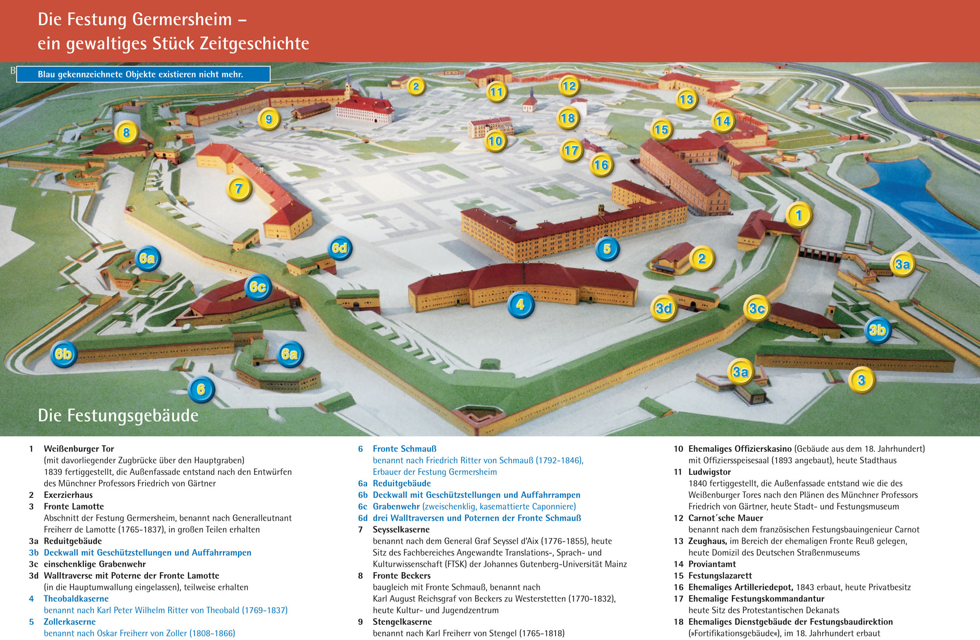
Structure of the Fortress Germersheim Structure of the Fortress Germersheim
The basic principle of the facility was the polygonal caponier system in a new Dutch form, or, as back then for fortresses of the German Federation mandatory so-called “New Prussian fortification form”. A system defined by caponiers or moat facilities and by casemated defensive buildings.
In a polygonal system, the floor plan is a polygon with straight or slightly bevelled fronts. Here in Germersheim are 6 front parts, Beckers, Schmauß, Lamotte, Diez, Reuß and Carl, that surround the city with 3.200 meters as the main rampart or city rampart in the “new Dutch form”. The infantry galleries of the main rampart started at the Fronte Diez, went through the Fronte Lamotte, Schmauß, Bekcers and a part of the Fronte Carl and had an overall length of about 1.800 meters. This part formed a dry moat system with a moat width of up to 32 meters. From the infantry gallery, a close defence was possible if the enemy was in the moat. But it was also possible to move troops underground without exposing them to the gire. The other 1.400 meters of the rampart had a wet moat system and therefore no galleries. It was supplied by the backflooding of the Queich at the Fronte Diez – flash lock to the Rhine – and the feeder of the “Altbach” – a side arm of the Queich – at the Fronte Carl.
In the middle of a front a building is situated into the moat from the rampart – the caponier or the moat facility. They are equipped with slits so that the moats can be taken under fire with cannons and weapons on the whole length. The parts to the West or Southwest were especially detailed as an attack from this side had to be expected. The caponiers of these parts from Schmauß and Beckers are therefore designed two-webbed like a horse shoe as are bigger number of cannons, six on each side, could have been used. The ones of the other fronts that were additionally secured by the landscape as Rhine, backwater and quagmire were one-webbed. The moat facility is separated from the rampart and because is lay deeper it was possible to shoot over it from the main rampart. These buildings were secured by a top rampart, also designed in a “new Dutch form”. As this laid in front of the moat facility it was smaller than the main rampart, so that it was possible to take over the distant defence from there over the top rampart. A 20-meter moat is connected here.
From the outer moat wall of the most important front Schmauß, Beckers, part of Carl and Lamotte, where often a connection gallery was built into the moat wall, a defence system started, whose underground halls lead outside into the “Glacis”. The main tunnel were 6-7 meters under the natural ground and 10 meters under the glacis edge. It was walled into brick stones and had a height of 1,87 meters until the vaulted zenith and a width of 1,14 meters. Smaller side tunnels lead off the main tunnel. These were 1,23-meter-high and 0,60-meter wide. Gun powder barrels would have been brought into the mine system in case of a war, which would have been blown up to interfere in the march.
Only the mine system was built from 1855 and 1681, for six years, so that a total building time added to 27 years.
Within the city more military buildings belong to the facility of the “New Prussian form”. Barrack facilities are not only barracks but so-called defensive buildings, that are mostly built parallel to the rampart in order to form a last defence possibility if the enemy got over the rampart.
The actual entrances to the fortress and therefore to the city were located in the North, the outward road to Speyer and in the East to the Rhine and are secured by two fortified gates, the Ludwigstor and the Weißenburger Tor.
The fortification is completed by the ten outworks around the main rampart in the Rayon areas, that spread to the right of the Rhine located Germersheim district parts. Among these the bridgehead near Philippsburg which secures the Rhine bridges together with the city fortification. These facilities of the belt fortification were built in a distance of 600-1700 meters around the city.
Quelle: Stadt Germersheim Quelle: City Germersheim Quelle: City Germersheim Quelle: ECCOFORT e.V. / OpenstreetMap Contributors
Nature Experience
Fortress hiking trails around Germersheim
Palatinate Forest association Germersheim: Ways through fortress and nature
For everybody who is light on his own feet, the Palatinate Forest Germersheim offers interesting routes rich in variety and tours through the city and the surrounding nature. As the area in and around Germersheim is flat, these tours are depending on length and time especially made for families with children but also for seniors.
A special round walk offers interested visitors the possibility to explore the combination of former military buildings and civil buildings as they are found on several places in the city and the fortress and very beautiful and natural locations, paths and places. Many seats and the upland clubhouse near Fronte Beckers invite to relax, rest and stay.
PWV Sondernheim: Between tread and Rhine meadows
The local group of the Palatinate Forest association Sonderheim offers beautiful footpaths and hiking trails between the tread and Rhine meadows for hikers and walkers. Take a rest for a little refreshment at the beautiful club house directly at the Rhine dike. The well-signposted hiking trail with the name “Rhine meadow and tread” shows the situation of the Rhine in the Upper Rhine low lands in its original form.
Discover and explore Germersheim and the beautiful surroundings. It is fun with fresh Palatinate air and there are many more things to discover.
Tree lesson path – worth seeing trees in Germersheim
The tree lesson path of Germersheim follows big parts of the former glacis area of the fortification built in the 19th Century. From the time of replanting the glacis rare tree species and exotics for this are were well-preserved in this are part.
The vegetation on the cemetery is also very remarkable. The round walk of the tree lesson path begins and end on the inner side of the Ludwigs Gate. Other hiking trails
other hiking trails
Barque trips on the Old Rhine and in the Rhine meadows
Gönnen Sie sich das pure Naturerlebnis in Germersheim
Treat yourself with pure nature in Germersheim
Explore the local flora and fauna from the water
Discover the habitat of local animals and plant on a fascinating barque trip through the Old Rhine. You are guided by skilled boat guides through the Rhine meadows and will experience the natural reserve in a special way.
The meadow area shaped by many floods has a unique flora and fauna. The impressions you get from the water will show you the diversity in animals and plants in a protected amphibious landscape form. Depending on the season, temperature and water level, the mostly under conservation being habitat offers fascinating experiences all over the year.
Watch mating rituals of drake mallards, while grey, silver, and purple herons look for food at the riverside. Besides cormorants, grey herons and ducks you can see, with a little luck, the rare kingfisher. In silverweed and cotton wood the cavity-nesting birds raise their offspring while you can hear mating calls from several frogs from the water moats in the background.
The wetlands are a true El Dorado for numerous kinds of dragonflies which hunts insects on the water surface in summer and are great to observe from the barques. With a little bit of luck, you can see schooling fishes spawn or watch nutrias.
From the end of August, when many migrating birds left already for the south, the grey heron and the tufted duck are coming back for the winter.
The barque trips are going from March to October. As these trips take place in a natural reserve the number is limited. Therefore, we ask you to book early. There are up to 12 seats available per boat. A trip through the Rhine meadows takes about 2 hours.
Offers
Quelle: Tourismus Germersheim Quelle: Tourismus Germersheim Quelle: Touismus Germersheim Quelle: Tourismus Germersheim